RASC Calgary Centre - A Complete Guide to
Right Ascension and Declination
By: Larry McNishCopyright © 2005- Larry McNish - All rights reserved.
Page last updated November 5, 2018
(Page originally created Dec 17, 2005)
Interested in Astronomy? Become a member of the RASC! Click here to find out about RASC membership and RASC publications. |
|
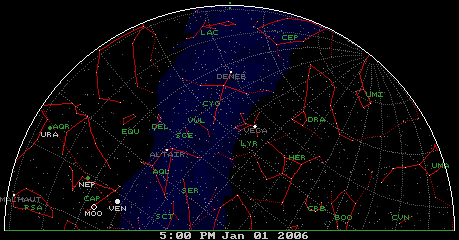
Finding Things in the Night Sky Every star, cluster, nebula, galaxy, radio source, and quasar has a position in the night sky. All the Solar System objects - the Sun, the Moon, the other planets, asteroids, and comets have their own motion across the background of stars, so for all these objects their sky position changes hourly or daily but can be mathematically predicted. All the textbooks, star charts, planispheres and "GOTO" computers refer to sky position coordinates - called Right Ascension and Declination. But; What are they?, Why are they necessary? and, How can you visualize them on the night sky? This web page is designed to assist the beginning astronomer in understanding these terms, and how to apply them, just as amateur and professional astronomers the world over use them to find everything in the night sky. Contents Use these links to go directly to a topic, or you can read all of them by scrolling from top to bottom. Your Observing Site Declination Right Ascension Sidereal Time The Ecliptic Putting it all together Polar View Eastern View Western View How to use it Precession Your Observing Site 1.  The first step in any observing session is to pick a safe observing site, and for us in the Northern Hemisphere,
it usually means one with a relatively clear horizon, especially towards the South.
The first step in any observing session is to pick a safe observing site, and for us in the Northern Hemisphere,
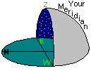
it usually means one with a relatively clear horizon, especially towards the South.The diagram at left will be used to show the observer (you) and your telescope at such a site on a clear dark night. Note that the observer is looking South, with East to your left, West to your right, and North behind you. Although we know the sky forms a complete dome over the observer, I will only show the "southern" half of the view in these diagrams or else they get too complicated. There is one more point of interest to the observer - the point directly above you (straight "up") which is called the Zenith. Note that this is not the position of Polaris - the Pole Star. In this diagram (for mid-northern latitudes), Polaris would actually be behind you in the Northern sky, and so it is not visible in this view. 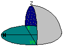 A "right side view" of the diagram above, A "right side view" of the diagram above,
 and where Polaris would be behind you. and where Polaris would be behind you.
2.  The next step is to know where you are and the current date and Local Standard Time. These are important because
as the Earth rotates on its axis every 24 hours and also as it revolves around the Sun every year, everything "up there" moves.
The next step is to know where you are and the current date and Local Standard Time. These are important because
as the Earth rotates on its axis every 24 hours and also as it revolves around the Sun every year, everything "up there" moves.A good, high-resolution topographical map or a GPS receiver can tell you where you are. Your Longitude West or East of Greenwich, England is measured in degrees from 0° to 180°. (By convention, all locations in the Western Hemisphere are specified as negative numbers so, for instance, Calgary is at (roughly) -114° Longitude.) An accurate watch, clock or cell phone can tell you the exact time. It is then up to you to know the local regulations concerning Daylight Saving Time in order to come up with the Local Standard Time. For instance in most of North America, during Daylight Saving Time, the Standard time is one hour less than the DST clock time.
3.  Directly South of you, curving from the South point on the horizon up to the Zenith, is an imaginary line in the sky known as
your Meridian. Everything in the sky left of your Meridian is rising and everything right of your Meridian is setting
- just like the Sun does. Everything on your Meridian has therefore reached its highest point in the sky tonight, and is therefore
at its best for viewing since it is as far as it can be away from the (murky) horizons. This is why it is important to choose a site with a
clear southern horizon in step 1. (When an object reaches this highest point in the sky we say it is at its Upper Culmination
(or usually we just say "Culmination". We'll talk about "Lower Culmination" later.)
Directly South of you, curving from the South point on the horizon up to the Zenith, is an imaginary line in the sky known as
your Meridian. Everything in the sky left of your Meridian is rising and everything right of your Meridian is setting
- just like the Sun does. Everything on your Meridian has therefore reached its highest point in the sky tonight, and is therefore
at its best for viewing since it is as far as it can be away from the (murky) horizons. This is why it is important to choose a site with a
clear southern horizon in step 1. (When an object reaches this highest point in the sky we say it is at its Upper Culmination
(or usually we just say "Culmination". We'll talk about "Lower Culmination" later.)Also - if you move to a different spot on the Earth, you get a slightly different view of the sky. If you move East you get to look at things that haven't risen yet at this location. If you move West you get to look at things that have already set at this location. If you move South you get to look at things that more northern observers cannot see. So, your Latitude and Longitude on Earth are two very important numbers since they, along with the date and time, determine exactly what portion of the sky you can see. [Optional reading: Mathematically, your exact longitude along with your Time Zone (both measured from Greenwich) and your exact Local Standard Time can be used to calculate a number known as your LMST - your Local Mean Sidereal Time. If you click on this link you will be taken to a page where this is done. One thing you will see is that since your LMST involves your clock time, it is constantly changing. Another is that your LMST does not depend on your Latitude. Everyone on the same N-S longitude line has the same Meridian and LMST. There will be more on this later.]
4.  So, Why do you need to know your Latitude? The answer is that your Latitude determines how far South you can see. The further
South you are, the more of the Southern Sky you can see (and less of the Northern sky).
So, Why do you need to know your Latitude? The answer is that your Latitude determines how far South you can see. The further
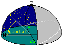
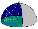
South you are, the more of the Southern Sky you can see (and less of the Northern sky).Now we have to think about the spinning Earth for a minute. The Earth spins on its N-S Axis. Polaris, the Pole star, is the star that happens to be nearest a line extended upwards from the Earth's North Pole. We can't see the South Pole region from North America. The North Pole of the Earth defines a point on the Celestial Sphere (the whole night sky) called the North Celestial Pole. Another very important reference is the Earth's Equator. If we extend the circle describing Earth's Equator out into the sky (as we did for its axis to find Polaris) it turns out that, if you make it a large enough circle, we can see it from "up here" in the Northern Hemisphere. , and the circular Equator defines a huge circle on the Celestial Sphere called, simply the Celestial Equator. Everything North of the Celestial Equator is called the Northern Sky, and everything South of it is called the Southern Sky - you may have been using these terms without realizing that it is all defined by a circle in the sky above the Equator. If you were on the Equator, this line would start due East, curve straight up to your Zenith and then curve straight down due West. If you were at the north Pole it would circle around your horizon just as the Equator is a circle around the Earth's axis. If you are in-between then the circle would still start exactly East and end exactly West, but would be "tilted" somewhere between your horizon and your Zenith. In fact, it would be tilted up from your Southern horizon by the amount 90° - your Latitude as shown in the diagram. The further South you go, the higher in the sky the Celestial Equator" would be. The further North you go, the lower it would be.
^ top Declination 5.  OK - so we used our Longitude to define our Meridian, and our Latitude to determine where the Celestial Equator would be. So, why is
this important?
OK - so we used our Longitude to define our Meridian, and our Latitude to determine where the Celestial Equator would be. So, why is
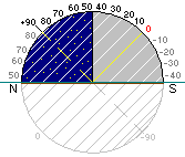
this important?The answer is that the whole coordinate system for everything up there is based on it. Let's start with Declination. If you can imagine the Celestial Equator in the sky where it crosses your Meridian, we have a pretty specific spot in the sky. This point is the starting point for Declination which is defined as "how far above or below the celestial equator is an object in the sky". Starting at 0° and going upwards to +90° is the Northern Sky. Starting at 0° and going downwards to -90° is the Southern Sky. In the "half-dome" diagram at left you can see that Declination increases upwards. It actually keeps on going over the observer's head and then back "down" towards the Northern horizon until it reaches Polaris! You can also see that from this location we can see a portion of the Southern Sky - not nearly as much as the Northern Sky, but at least some of it. From here, we can see the entire Northern Sky (over the year) and, we can see down to a Declination of -(90° - your Latitude). For Calgary at 51° North, this means we can see any object with a Declination from +90° to about -39° (depending, again, on the Southern horizon visibility). 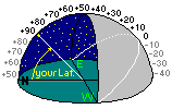 Side view of a Declination Arc for an observer at 45° Latitude. Side view of a Declination Arc for an observer at 45° Latitude.
6.  Ok - Another thing about Declination:
It's a bit tricky to see, but if we make up a Declination grid, all the lines have the following characteristics: - they all meet at the N and S Celestial Poles, - they all cross the Celestial Equator at a right angle (just like N-S lines of Longitude do on Earth) - Declination is always measured + and - from the Celestial Equator The Diagram at left shows several lines for measuring Declination - useful for things that are not on the Meridian. Note that southern objects (for instance at Declination of -20°) "set" before reaching the Western horizon. They also "rise" from a position that is more southerly than the Eastern horizon. Again, a clear southern view is necessary if you want to be able to see these objects. 7.  Ok - a few more things about Declination before we move on:
If we "join" all the same values of Declination in the image above (e.g. all the +10° points etc.) we get "lines of constant Declination" as shown at left. All these lines are actually parallel to each other and never meet. This also shows that southern objects (like those at -30°) rise south of East, set south of West, and are visible for a much shorter time than more northerly objects. [Optional reading: For really accurate measurements of positions, 10° lines or even 1° lines are not enough. Each degree of Declination is divided into 60 minutes of arc (abbreviated min or ' ) and each of those minutes is divided into 60 seconds of arc (abbreviated sec or " ). Therefore a really accurate Declination position might be specified as +30 deg 15 min 41 sec or +30° 15' 41". For even greater accuracy, the seconds value might be shown with a decimal fraction such as +30° 15' 41.03", and if you want to convert the entire thing into decimal degrees the formula is: Declination = degrees + (minutes / 60) + (seconds / 3600) which, for the example of +30° 15' 41.03" results in a value of +30.2613972 degrees.]
^ top Right Ascension 8.  If Declination is the "up-down" coordinate, then what is the "left-right" coordinate?
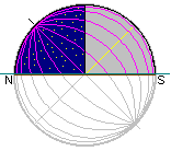
The answer is Right Ascension. If you could take a flat star chart that has grid lines for locating things on it and hold it up to the sky and then bend it so that it fits into the bowl of the Celestial Sphere, the result would be like the diagram at left. The purple lines on the diagram represent left-right divisions, except that they are all curved. You have seen lines like this above where we drew several lines from which we could measure Declination. Each of these curved lines is like a N-S longitude line on the Earth - they all meet at the poles and they all cross the Equator at a 90° angle. But how to label them? They are not nearly as fixed in the sky as Declination, since the Earth is constantly rotating bringing new grid lines up from the East, and loosing those low in the West. So a fixed degree system based on the Pole and the Equator just won't work. They need to be tied into the fact that Earth rotates every 24 hours and this is an amount of time. So, that was it - they divided the sky map into 24 bands from left-to-right and labeled them as "hours" meaning that it took approximately 1 hour for each of them to move a distance equal to its width across the sky. The lines defining these bands therefore became the logical choice for a grid system, and it was based on things in the sky - not on the Earth's poles or equator. So each object was catalogued as being at a certain point in Declination and would appear at a certain "hour angle". In other words, if you stood outside and looked at the sky for several hours you would see the stars seem to move across your Meridian from East to West at that rate. Note that since everything is rotating constantly, the Right Ascension "value" on both the East and West horizons and your Meridian changes continuously - every minute of the night.It also changes every day of the year as Earth goes around the Sun - but that's the next topic. So, where to start this numbering system - every point in the sky crosses your Meridian each day, and every spot on Earth has a slightly different exact local time (remember - this was before Standard Time Zones were invented). The choice could not be given to one preferred city on Earth - it had to be based on the stars. The choice was the "Vernal Equinox" - i.e. the point in the sky where the Sun was at the time of the March Equinox. From that specific point on the Celestial Equator, they simply numbered the "hours" 0, 1, 2, 3, and so on up to 22, 23, and 24 was made the same as the 0 line. The trick was, they numbered them to the East (i.e. to the left) since that is the order in which the lines rise up from the Eastern Horizon - so the numbers get larger to the East (left). So now we had a grid system we could draw on paper and from the starting points of 0° Declination and 0 hours of Right Ascension we could chart everything in the sky, and use this map anywhere on Earth.
Due south of you, your Meridian defines your exact local time and since we now map stars by time, this is called your local "star time" or LMST - your Local Mean Sidereal Time. This is just the star's Right Ascension value from the map for that star. [Optional reading: For really accurate measurements of positions, "hour" lines are not enough. Each of these represented an hour of time, and therefore, for greater accuracy they sub-divided these "hours" into 60 "minutes" and each minute into 60 "seconds" (of time). It is slightly confusing to use the same terms as the subdivisions of degrees, but remember, all these lines curve up to the poles where they meet, so the value is not an angle of separation since the separation keeps getting smaller and smaller on the sky till there is no angular separation at all at the poles, yet the sky still takes 24 hours to rotate, even at the poles. Therefore a really accurate Right Ascension position might be specified as 3 hours 15 minutes 41 seconds or 3h 15m 41s. For even greater accuracy, the seconds value might be shown with a decimal fraction such as 3h 15m 41.03s, and if you want to convert the entire thing into decimal hours the formula is: RA = hours + (minutes / 60) + (seconds / 3600) which, for the example of 3h 15m 41.03s results in a value of 3.2613972 hours. Right Ascension is never negative or greater than 24 hours.] ^ top Sidereal Time 9. The Diagram below (not to scale) attempts to show one day in Earth's orbit around the Sun. The upper portion of the diagram shows that one day is approximately 1° along Earth's Orbital path. The lower portion attempts to show the Earth's 24 hour rotation during that day - viewed from somewhere above the North Pole.  Things to notice in the diagram above.
Now look at the white dot and the purple line from that spot on Earth to a distant Star. Each "day" we go a little past the point where we once had a view of that star on our Meridian. Or, conversely, each night our Meridian points to a different star. In fact, if we time the Earth's rotation using our 24 hour "Sun" clock, we would see a star reappear on our Meridian 23 hours and 56 minutes later. This 4 minutes per day difference totals about 1461 minutes per year or slightly more than a full day. So, relative to the stars the Earth makes an additional rotation over the year. It is this slight additional rotation per day that causes the summer constellations to set is the West as the Winter constellations rise in the East - in other words it gives us a chance to see the whole sky, at night, over the course of a year. We call the 23hr 56min period a Sidereal "Day" - the time it takes for the Earth to rotate relative to a star. This has the effect of sliding our star chart to the right by 4 minutes of Right Ascension per day, in addition to the complete rotation of 24 hours of Right Ascension it makes. These two factors combine so the Right Ascension of everything up there changes not only every hour, but every day they slide a little further to the West. Finally - putting all this Right Ascension stuff together: If you want to see an object that is catalogued as "Right Ascension xx hours" then it will be on your local Meridian when your LMST is "xx hours". You can either go out on a night before then, and wait a few hours for it to be there, or wait for the appropriate day and go view it on the Meridian right away. Since there are 24 hours of Right Ascension and 12 (roughly equal) months in the year, the time a constellation is on or near the Meridian changes about 2 hours each month (or roughly 1 hour every 2 weeks) as the Earth progresses in its orbit around the Sun. [Optional reading 1:]
^ top The Ecliptic If the Earth orbited the Sun standing "straight up and down", then the Equator (both Earth's and the Celestial Equator) would be parallel to the Earth's orbital plane. The Sun would never deviate from the Celestial Equator, and all the other planets in their orbits would be found close to the Celestial Equator as well. Of course this would also mean we wouldn't have seasons since the Sun would rise at the same point due East, follow the Celestial Equator path, and set at the same point due West every day of the year. But this is not the case. Planet Earth's North-South axis is tilted 23.4393° with respect to the plane of the Earth's orbit (called the Ecliptic Plane, so we are rotating at an angle with respect to the way we go around the Sun. Click the image below to open a new window with a 184 KB animation of the way the Earth rotates. (Close the new window when you are finished with it.) animation  This tilt causes the changing seasons, because it sometimes tips the Northern Hemisphere towards the Sun (in the Summertime) and on the opposite side of our orbit, tips the Northern Hemisphere away from the Sun (in the Wintertime) - see the diagram below. From the Earth, this is seen as the Sun getting higher in the sky during the Summer, finally reaching its highest point at what we call the "Summer Solstice" around June 21, and lower in the sky during the Winter, finally reaching its lowest point at what we call the "Winter Solstice" around December 21. This apparent path of the Sun's motion on the celestial sphere as seen from Earth is called the Ecliptic. It results from us looking from the Earth to the Sun i.e. along a line joining the Sun to the Earth's orbit - not the Earth's Equator. The path of the Sun over a year is therefore another great circle in the sky, but it is tilted from the Celestial Equator the same amount as Earth's axis tilt: 23.4393°. When the Earth's tilt causes the Northern Hemisphere to be tipped towards the Sun, the Sun's path (the Ecliptic) and the Sun can be found high is the daytime sky. When the Earth's tilt causes the Northern Hemisphere to be tipped away from the Sun, the Sun and the Sun's path (the Ecliptic) can be found low is the daytime sky.  As can be seen in the diagram above, the situation is reversed on the night side of the Earth. When the Sun's path is highest in the daytime sky (in Summer) the Ecliptic is lowest in the nighttime sky. And vice-versa - when the Sun's path is lowest in the daytime sky (in Winter) the Ecliptic is highest in the nighttime sky. This makes it easier to see the other planets and asteroids in the Wintertime since the Ecliptic plane (also the plane of the Solar system) reaches its highest point away from the (murky) horizon and all the planets (except Pluto) are never found far from this line. These two great circles in the sky - the Celestial Equator and the Ecliptic - are tilted, but cross each other at two points (kind of like they were hinged there). These two points are called the "March Equinox" around March 21, and the "September Equinox" around September 21. 10. 
When is the Ecliptic highest or lowest in the sky? The Celestial Equator always appears at the same position in your sky. However, since the Ecliptic is "tilted" with respect to that line, it seems to pivot about its centre as the Earth rotates and also as the Earth revolves around the Sun. Since the Earth rotates once a day, the Ecliptic seems to go through this pivoting cycle each day. Therefore, there is a time each day when the Ecliptic is at its highest, lowest, and intermediate points. Since the Ecliptic passes through the constellations of the Zodiac, those constellations appear at different heights along with the Ecliptic. Since the planets orbit close to the Ecliptic they also appear at different heights along with the Ecliptic. Where the Ecliptic arcs through the sky depends on:
^ top Putting It All Together
^ top Polar View OK - we've covered Declination and Right Ascension looking South, but what about looking North? First, you have to turn around to look north, so now East is on your right and West is on your left. This means objects rise from your right side and set on your left side (if they "set" at all). Some high-Declination constellations are "circumpolar" meaning they circle the pole star and never "set" so they are visible every night of the year. Other (lower) constellations are visible only for a range of months, depending on your latitude and its average Declination. In addition, these constellations rise and set daily like the Sun and the planets do, so, the time of night that you are out stargazing also matters. Click on this link to open another page from this RASC site which contains information on observing the constellations, or, consult a planisphere, one of the many PC or Mac based planetarium software packages, or one of the many other internet sites to see what constellations are visible on any given night.
Earlier I said I'd talk about "Lower Culmination" later - and now's the time. Early in this article we noted that an object reaches "Culmination" or "Upper Culmination" when it rises up to its highest point in your sky and crosses your Meridian. But if you look at the animation above, you can see that many circumpolar objects near the North Celestial Pole cross your Meridian twice each day - once when "circling" from East to West, and again 12 hours later as it passes under Polaris circling back from West to East. So we had to clarify the definition of "Culmination" depending on where you are looking. When far-northern objects cross your Meridian "below" Polaris we call it the object's "Lower Culmination". In either direction, "Upper Culmination" is the time at which the object is highest in your sky and at its best for viewing or photographing. ^ top Eastern View OK, we've covered looking South, and looking North. But what about looking East?
Notice that the Celestial Equator looks like a straight line rising diagonally up and right from the East point on the horizon. Objects to the left of it (those with positive Declinations) appear to diverge and curve up and to the left of the Celestial Equator, heading towards their path over Polaris. Objects to the right of it (those with negative Declinations) appear to diverge and curve below and to the right of the Celestial Equator, arcing across the sky to the south. ^ top Western View OK, now we've covered looking South, North and East. But what about looking West?
Now the Celestial Equator looks like a straight line dropping diagonally down and right towards the West point on the horizon. Objects above it (those with positive Declinations) appear to start converging with it curving down and to the right of the Celestial Equator, after their path over Polaris. Objects below it (those with negative Declinations) set earlier than the Celestial Equator, arcing across the sky to the south west. ^ top How to use it 1. The type of telescope mounting you have determines what you have to do in order to "track" an object as it rotates across the sky. 2. The type of mount also determines how you re-point the scope to various objects. 1. Following Objects across the Sky
2. Re-pointing to different objects
^ top Precession Now that you think you have Right Ascension and Declination pretty well figured out, it's time to learn that it's even more complicated than the long description above. Every Right Ascension and Declination coordinate moves over a long period of time, due to the fact that the Earth's North-South rotation axis "wobbles" like the slow rotational tilting of a spinning top. This is known as Precession and affects the direction in the sky to which the North Pole points, and where the Celestial Equator is found. Since the entire Right Ascension and Declination coordinate system was based on those two values, this is a pretty important effect. (Although it is often called the "Precession of the Equinoxes" you should realize that it would affect not just the positions of the September and March Equinoxes, but everything based on Right Ascension and Declination.) Precession is caused by the gravitational attraction of the Sun (and the Moon) tugging on the Earth's equatorial bulge - trying to "level" it from its 23.4393° tilt, but never winning. Due to the laws of motion (and something called "angular momentum") the axis keeps its tilt, but the tugging force causes the axis to wobble around in a circle rather than "straightening" up. The Greek astronomer Hipparchus of Rhodes (190-120 B.C.) discovered that, due to the "wobble" of the Earth's axis as it spins like a top, the North-South axis line (the North Celestial Pole) pivots around a point in space known as the North Ecliptic Pole which is "straight up" from the Ecliptic - the plane of the Earth's orbit around the Sun. One revolution around this point takes a period of approximately 25,770 years (Beatty et al. 1990) commonly quoted as the "26,000 year precession of the equinoxes". The moving N. Celestial Pole also determines which star is nearest the northern axis line of the Earth on the Celestial Sphere and which one is therefore the "North Star". Thuban (in southern Draco) was the "pole star" around 3000 BC. The next naked-eye star that served as the Earth's pole star was Kochab in the bowl of the Little Dipper from about 1900 BC to 1100 BC. Due to precession, the current holder of the title "pole star" is Polaris which, at present, is slightly under 1° away from the pole of rotation. Polaris is due to become an even more accurate pole star in the near future - the distance between Polaris and the pole will reach a minimum of just under 1/2° in the year 2100. After that, Alderamin in Cepheus will be the Pole Star around 7500 AD, Deneb in Cygnus will be the Pole Star around 10,000 AD and Vega will become the North Star in about AD 14,000 (see the first diagram below). Due to this "wobble" all the coordinates of the "fixed stars" slowly change. (Over thousands of years, the relative positions of all the stars also change due to their own motion through the galaxy, but this is not part of Precession.) Since the constellations "contain" the stars within their borders, the constellation borders must also change with Precession. Finally, since we base the positions of all moving Solar System objects on our coordinates - these must also take precession into account when they are calculated. Thankfully, this is a fairly small angle change each year, but it builds up over time so that every 50 years we need to re-publish all the Right Ascension and Declination coordinates. This is called the epoch (i.e. date) of the coordinate list. You will find many old textbooks using epoch 1950 and all newer texts using epoch 2000. By the time your grandchildren get interested in Astronomy, they will probably be deciding whether to use epoch 2000 or 2050. Oh, and one last thing. Since Precession affects the direction of the tilt of Earth's axis, it will eventually reverse the angle so that when we reach the point in our orbit where we used to have Winter (Earth's axis pointing the Northern Hemisphere away from the Sun) we will then have Summer (Earth's axis pointing the Northern Hemisphere towards the Sun). So, if you can wait about 12,000 years, all those beautiful Winter constellations (like Orion) will finally be visible on hot summer nights (see the second diagram below). a huge counter-clockwise circle in the northern sky as seen from the Earth. The angular diameter of this circle is twice the tilt of Earth's axis - approximately 47° across.  The Earth's Orbital Motion and Precession 
More on Precession: http://www.jgiesen.de/astro/precession/index.html http://en.wikipedia.org/wiki/Precession http://www.seds.org/~spider/spider/ScholarX/coord_ch.html | ||||||||||||||||||||||||||||||||||||||||||||||||||||||||||||||||||||||||||||||||||||||||||||||||||||